MAPinr - KML/KMZ/OFFLINE/GIS
- Travel & Local
- 4.1.2
- 76.3 MB
- by Xylem Technologies
- Android 6.0+
- Apr 26,2025
- Package Name: at.xylem.mapin
Welcome to Mapinr, where managing your KML/KMZ/GPX files is made easy. With our GIS capabilities, you can measure distances, log GPS data, utilize WMS, and even access offline maps. Mapinr is designed to enhance your experience with a suite of tools perfect for both professional and recreational use.
We understand the challenges posed by the rapid evolution of Android versions, especially for non-profit projects like ours. Despite these challenges, we are committed to keeping Mapinr alive and aligned with our vision of delivering a secure, privacy-friendly, and affordable app. We acknowledge that Google Play Store's minimum Android version requirements can exclude many devices. That's why we offer downloads for versions below Android 14 on our website.
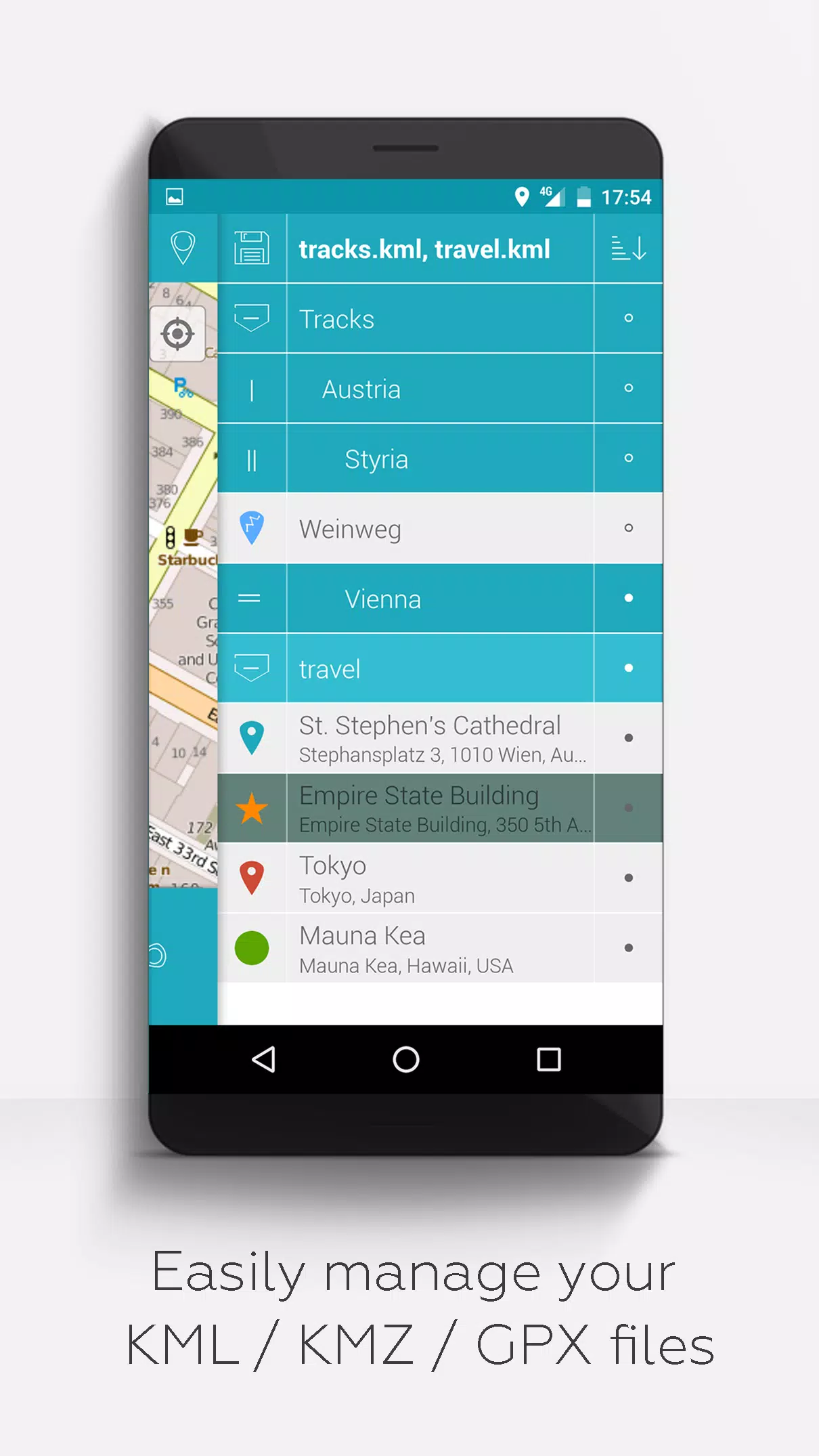
Are you looking to manage your own points of interest or to pin your pictures on a map? Mapinr is your solution. This ad-free Android app is tailored for handling kml/kmz files and displaying gpx files on various maps. Whether you're a professional or enjoy activities like hiking, cycling, running, or skiing, Mapinr is designed to meet your needs.
We value your feedback and are eager to hear about any issues or ideas you have for improving Mapinr. Please send your thoughts and suggestions to [email protected]. We appreciate your patience and understanding, especially when it comes to software bugs, as our resources are limited and we cannot implement every suggestion.
Mapinr offers a comprehensive set of features:
- Ad-free experience
- Hierarchical folder structure for organizing multiple kml/kmz/gpx files
- Capabilities to create, load, edit, save, import, export, and share kml/kmz files
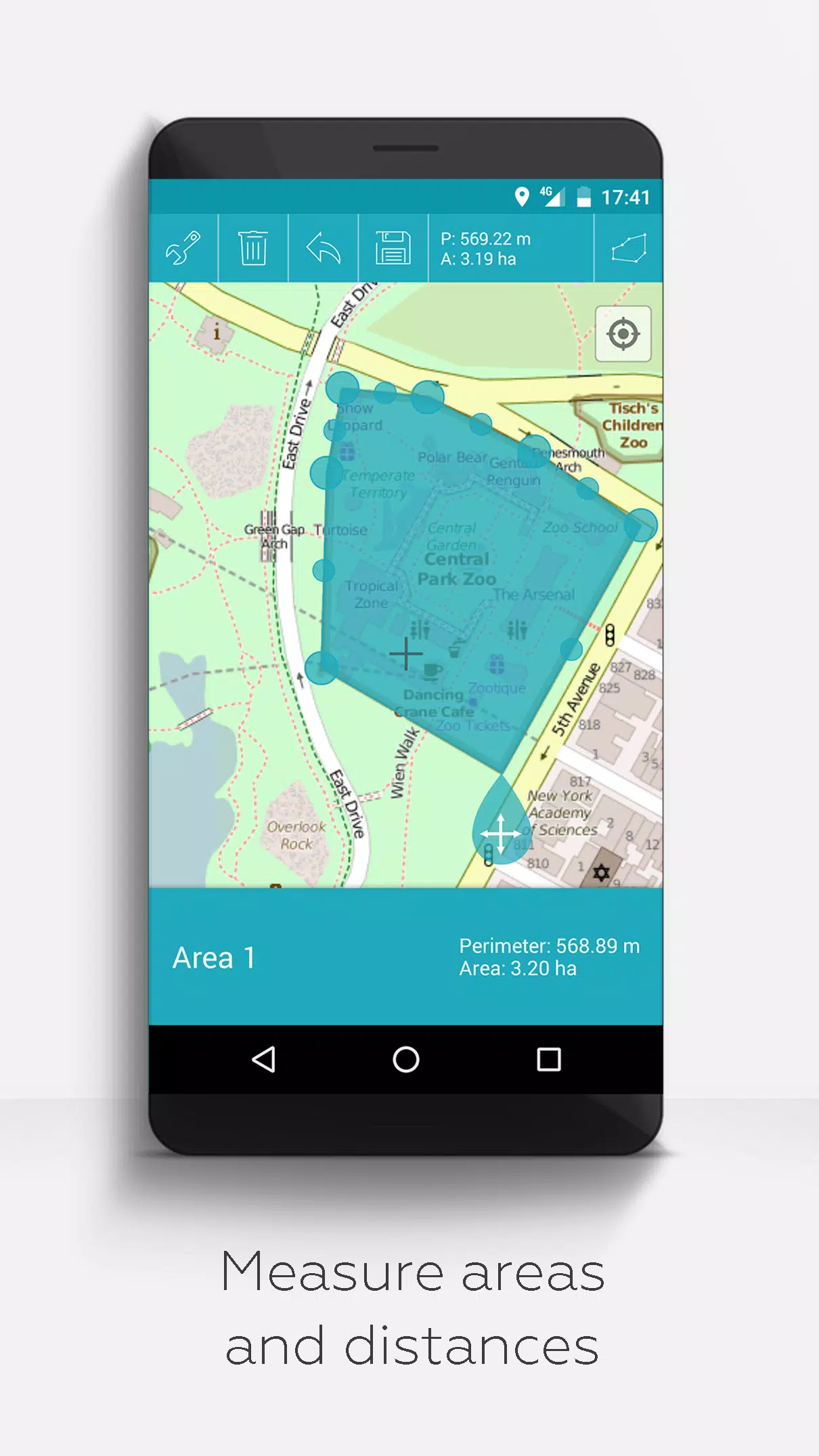
- Create, load, edit, save, import, export, and share waypoints, lines/tracks, and polygons
- Add pictures to waypoints to create photomaps
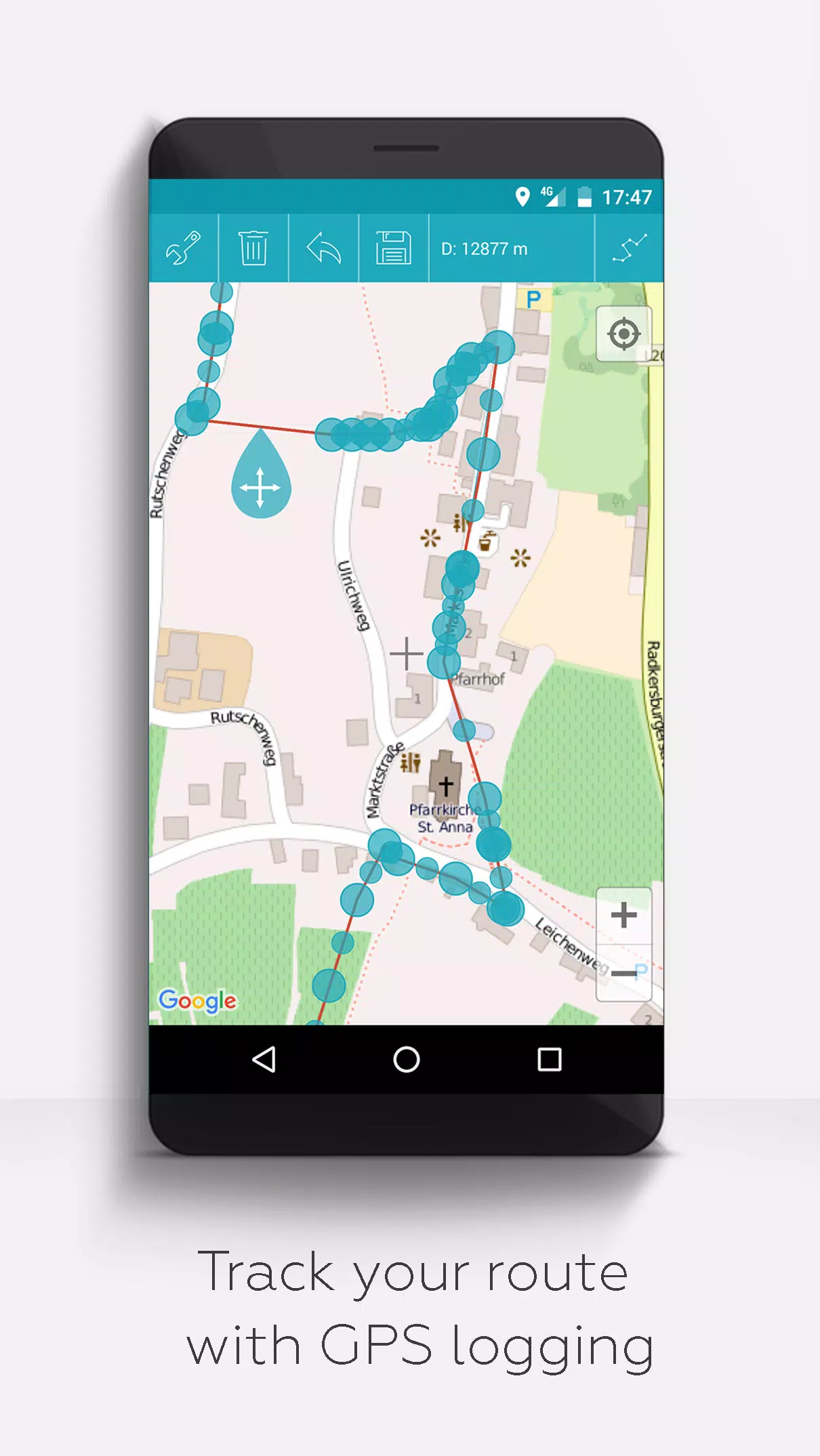
- Display waypoints, lines/tracks, and polygons on various maps including Maps, Satellite, Hybrid, OpenStreetMap, Opentopomap, and Opencyclemap
- Share coordinates of waypoints
- Customize colors of waypoints, lines/tracks, and polygons
- Open exported kml/kmz files in other apps
- Search by name, address, and coordinates
- Location-sharing feature to inform friends of your whereabouts
- Display multiple kml/kmz/gpx files at the same time
- Merge kml/kmz files
- Cloud integration for easy data management
- Measure distances and areas directly on the map
- Available in multiple languages including English, Spanish, Lithuanian, and Polish
Extended features, which can be unlocked with donations or by showing support on LinkedIn and activated in the settings, include:
- Download free offline maps from OpenStreetMap
- View GPX files
- Access arbitrary map data using Web Map Service (WMS), such as opendata from www.data.gov
- Create custom metadata
- Upload and use custom icons
- Record GPS tracks
Unlike other related apps, Mapinr respects your privacy and does not engage in data mining or selling. Donations to Mapinr are voluntary contributions that support our non-profit efforts.


-
 "Defeating the Viper in The First Berserker: Khazan - Strategies Revealed"
In the *Dungeon Fighter Online* universe, the dragonkin have long been a formidable challenge for heroes, and this continues in *The First Berserker: Khazan*. Facing the Viper, a high-ranking dragonkin created by Hismar to lead defeated dragons and sow chaos, requires strategic caution. Here's how t
Apr 26,2025 -
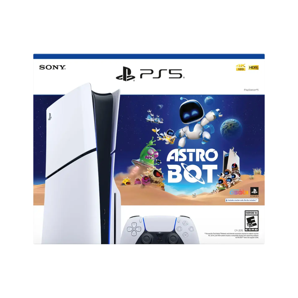 PS5 Astro Bot Bundle Is Now Available, and Includes 2024 GOTY Winner for Free
If you're considering purchasing a PS5 in 2025, the PlayStation 5 Slim Astro Bot bundle stands out as an exceptional deal. The Disc model is currently available at Best Buy for $449.99, while the Digital Edition can be found at Amazon for $399.99, with wider availability expected soon.What sets this
Apr 26,2025 - ◇ "Snaky Cat: Slither, Compete, and Outlast Opponents in New Game" Apr 26,2025
- ◇ Scarlet Girls Tier List for the Best Characters Apr 26,2025
- ◇ "Metal Gear Solid Delta: Snake Eater Release Date Unveiled in New Trailer" Apr 26,2025
- ◇ What Are Bookshelves and Why Are They Needed Apr 26,2025
- ◇ Unveil 5 Secret Missions in Pokemon TCG Pocket: Space-Time Smackdown Completion Guide Apr 26,2025
- ◇ Mirren: Star Legends - A Beginner's Guide Apr 26,2025
- ◇ Touchgrind BMX 3: Rivals Renamed from Touchgrind X Apr 26,2025
- ◇ "Prison Gang Wars: A Gritty Simulation of Incarcerated Life" Apr 26,2025
- ◇ Izuna's Backstory and Skills in Blue Archive Revealed Apr 26,2025
- ◇ Alienware 4K OLED Gaming Monitor Now at Lowest Price Ever Apr 26,2025


- 1 Pokémon GO Set To Roll Out Safari Ball In The Wild Area Event 2024 Nov 10,2024
- 2 Marvel's Spider-Man 2 Swings to PC in January 2025 May 26,2023
- 3 Tomorrow: MMO Nuclear Quest Is a New Sandbox Survival RPG Nov 15,2024
- 4 Black Myth: Wukong Review Fallout Nov 13,2024
- 5 Roblox Ban in Turkey: Details and Reasons Mar 10,2024
- 6 Final Fantasy XVI PC Port Falls Short Nov 14,2024
- 7 GTA 6 Raises The Bar and Delivers on Realism Beyond Expectations Nov 10,2024
- 8 Dragonite Cross-Stitch Captivates Pokémon Enthusiasts Nov 08,2024


-
Best Racing Games to Play Now
A total of 10
-
Explore the World of Shooting Games
A total of 10
-
Best Free Simulation Games for Your Android Phone
A total of 4